Connect with us

Subscribe

Subscribe

Travel

Tropical Storm Erin is about to Become a Serious Problem.

The climatological peak of hurricane season is just four weeks away, and Erin is showing us exactly why preparation matters.

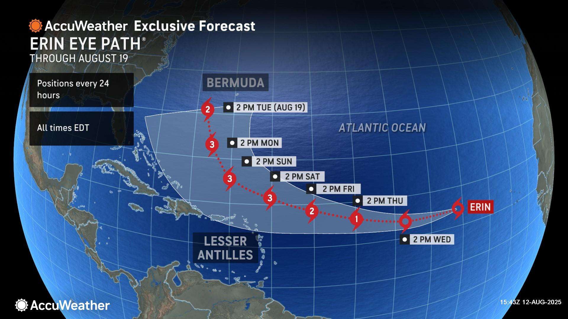
This weekend, we’re looking at what could develop into a major hurricane, and Puerto Rico is directly in its path. If you’re anywhere in the northeast Caribbean, this isn’t the time to take chances.

Here’s what’s coming: Erin will slam Puerto Rico with heavy rain and dangerous winds as it moves north this weekend. We’re talking about 1 to 2 inches of rain across most of Puerto Rico and the U.S. Virgin Islands, but some areas could see up to 7 inches. That’s flash flooding territory.

The wind situation is equally concerning. Northern Puerto Rico should brace for gusts between 40 and 60 mph, with some areas potentially seeing gusts near 80 mph. Power outages are almost inevitable.

Here’s what everyone needs to understand; this storm’s reach extends far beyond the Caribbean.

Erin is going to create dangerous beach conditions from Florida all the way up to Maine. We’re talking about rough surf and deadly rip currents that will persist from this weekend into next week. Beach erosion is a real possibility in vulnerable areas.

Let’s be clear about something: more than 50 people have already died in surf zones across the United States and Puerto Rico this year due to rip currents, high surf, and sneaker waves. This storm will make those conditions significantly worse.

The Caribbean is just the beginning.

Environmental conditions are perfect for this storm to intensify rapidly once it moves northeast of the Lesser Antilles. From Saturday through Monday, areas from Saint Martin to Puerto Rico experienced the worst of it: heavy rain, dangerous winds, localized flooding, and treacherous seas.

What happens next depends on atmospheric steering patterns that are still developing.

The storm’s ultimate path will be determined by the positioning of the Bermuda High, jet stream patterns over the U.S., and a cold front moving off the East Coast. Right now, there are two main scenarios: either the storm curves away from the U.S. coastline, or it tracks uncomfortably close to it.

Current forecasts show Erin staying hundreds of miles offshore as it moves parallel to the East Coast, but that can change. Everyone from Florida to Atlantic Canada needs to pay attention to updates this week.

The bottom line: We’re approaching peak hurricane season, and this is exactly the wrong time to be unprepared.

Check your emergency supplies. Review your evacuation plans. Make sure your insurance is current. The climatological peak of hurricane season is just four weeks away, and Erin is showing us exactly why preparation matters.

AccuWeather is also tracking four other areas of potential tropical development in the Atlantic basin, which means this busy season is far from over.

Risk Assessment:

  • High risk: Puerto Rico and northern Leeward Islands (Friday-Tuesday)
  • Medium risk: Northern Hispaniola, Lesser Antilles, eastern Bahamas (Aug. 15-19)
  • Medium risk: Eastern Nova Scotia (Aug. 20-24)
  • Low risk: Central and eastern Gulf Coast, Florida, entire East Coast

There’s also potential tropical development in the Gulf on August 12 that could bring localized flooding to the northern Gulf Coast through Tuesday night.

This is not a drill. Take it seriously.

Newsletter Signup

Stay in the loop with exclusive news, stories, and insights—delivered straight to your inbox. No fluff, just real content that matters. Sign up today!

Written By

Click to comment

Leave a Reply

Your email address will not be published. Required fields are marked *

Trending

The Warnings We Ignored

Featured Cover Story

What It Means to Be a Lifelong Supporter: Larry Weltman on Loyalty, Community, and the Beautiful Game

Sports

Sharon Marley Reclaims Her Voice

Women Empowered

Toronto Collides Into New Culture

Entertainment

Advertisement
Newsletter Signup

Stay in the loop with exclusive news, stories, and insights—delivered straight to your inbox. No fluff, just real content that matters. Sign up today!

Legal and Advertising Disclaimer: Advertisements, sponsored content, business listings and other promotional materials are supplied by third parties. Their publication does not constitute an endorsement, recommendation, representation, warranty or guarantee by TCN Now Inc. Advertisers and content providers are responsible for the accuracy, legality and substantiation of their claims and for obtaining all necessary copyright, trademark, privacy and other permissions. To the fullest extent permitted by law, TCN Now Inc., its directors, officers, employees, contractors and affiliates shall not be liable for any loss, damage, cost, expense or claim arising from third-party advertisements, products, services or promotional content. TCN Now Inc. reserves the right to refuse, edit, suspend or remove advertising or promotional content at its discretion. Editorial and Content Disclaimer: The opinions, commentary and viewpoints expressed in signed articles, columns, letters, guest submissions and other contributor content belong to the respective authors and do not necessarily reflect the opinions or views of TCN Now Inc., its directors, officers, employees, editors or affiliates. Content published by TCN Now Inc. is provided for general informational purposes only and is not intended as legal, financial, medical or other professional advice. While reasonable efforts are made to ensure accuracy, TCN Now Inc. does not guarantee that all information will be complete, current or free from error. To the fullest extent permitted by law, TCN Now Inc. disclaims liability for losses or claims arising from reliance upon contributor opinions, third-party submissions or general informational content. Copyright © 2026 TCN Now Inc. All rights reserved. Unless otherwise stated, the text, photographs, graphics, logos, designs and other original content appearing on this website are owned by or licensed to TCN Now Inc. and may not be copied, reproduced, republished, distributed, modified or commercially used without prior written permission, except as otherwise permitted by law. Third-party names, logos, trademarks and content remain the property of their respective owners.

Connect
Newsletter Signup

Stay in the loop with exclusive news, stories, and insights—delivered straight to your inbox. No fluff, just real content that matters. Sign up today!